The glacial tills and Carboniferous limestone underlying Naas present a specific challenge: depth to bedrock can shift from 2 metres to over 15 metres across a single site. We have seen foundation designs fail at tender stage because the ground model assumed uniform rockhead. Vertical Electrical Sounding (VES) cuts through that uncertainty. A Schlumberger array with AB/2 up to 150 metres images resistivity contrasts that distinguish compact limestone from saturated gravel lenses. For sites near the Grand Canal or along the M7 corridor, where fill thickness varies unpredictably, resistivity data, calibrated with a few test pits, reduces borehole count and gives the geotechnical engineer a continuous profile rather than isolated point data. Our field crew operates across Naas, Sallins, and Johnstown using a 4-point resistivity meter with automatic stacking to suppress cultural noise from overhead lines and buried services.
A VES sounding line across a 60-metre profile in Naas can resolve the soil–rock interface faster than three boreholes, and without breaking ground.
Service characteristics in Naas
Risks and considerations in Naas
The most common mistake we see in Kildare is relying on trial pits alone to prove rockhead across a sloping site. A pit reaches 3 or 4 metres and stops; the client assumes competent limestone is continuous. Later, excavation for a deep drainage run hits a buried channel filled with soft peat and silt at 6 metres – a problem a VES line would have flagged in half a day. Karstified limestone introduces another risk: cavities or dissolution features can go undetected between boreholes, leading to differential settlement beneath pad footings. VES is not a standalone solution, but it is the fastest reconnaissance tool to screen for lateral variation before committing to an intrusive investigation layout. When we pair resistivity profiles with targeted cpt test soundings, the ground model tightens considerably, and the client avoids expensive redesign during construction.
Our services
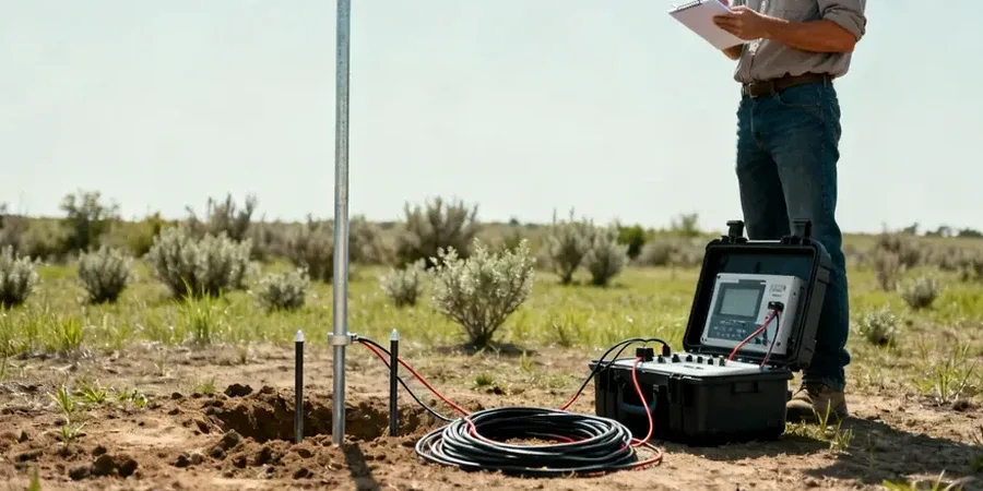
Our electrical resistivity service in Naas covers the full workflow from field acquisition to interpretative reporting. Each survey is tailored to the site geometry and the target depth.
1D Vertical Electrical Sounding (VES)
Single-location depth sounding using the Schlumberger configuration. Ideal for determining overburden thickness and bedrock rippability at a proposed foundation location.
2D Electrical Resistivity Tomography (ERT)
Multi-electrode profile along a survey line, producing a continuous cross-section of resistivity. Best suited for detecting lateral changes, buried channels, and karst voids.
Groundwater and plume mapping
Resistivity profiling to locate the water table, track leachate migration, or delineate saline intrusion in alluvial gravel aquifers south of Naas.
Resistivity data integration and reporting
Joint interpretation of resistivity sections with borehole logs, CPT data, and laboratory test results. Deliverables include fence diagrams, iso-resistivity maps, and a factual report compliant with I.S. EN 1997-2.
Quick answers
How much does a VES survey cost for a typical residential site in Naas?
A single VES sounding with interpretation typically falls between €610 and €920, depending on the maximum AB/2 spread required and the number of cycles stacked per reading. For a 2D resistivity line across a standard 0.2 ha plot, the cost is higher and includes electrode setup, data acquisition, and a geophysical report. We provide a fixed quote after reviewing the site location, target depth, and any access constraints.
Can VES distinguish between limestone and sandstone bedrock in the Naas area?
Yes, in most cases. The Waulsortian limestone common around Naas has a resistivity above 1000 ohm·m when competent and dry, whereas sandstone of the same age typically reads between 200 and 600 ohm·m. The contrast is clear on an inverted VES curve, especially when calibrated against a known borehole log. Saturated or clay-filled fractures can lower limestone resistivity, so we always recommend at least one control point to anchor the geophysical interpretation.
How long does a VES survey take on site?
A single VES sounding to 80 metres depth takes about 45–60 minutes for our two-person crew, including electrode layout, measurement, and pack-up. A 2D resistivity line of 120 metres with 48 electrodes takes roughly two hours. We can usually complete data acquisition for a typical house plot in one morning, with the processed report delivered within three working days.
Will buried utilities or overhead power lines affect the resistivity readings?
They can, and we take specific steps to manage it. Overhead high-voltage lines induce 50 Hz noise that we filter during acquisition. Buried metallic pipes or cables create a low-resistivity anomaly that appears on the apparent resistivity curve. Before starting, we request utility maps and walk the line with a cable locator. We offset the survey line by at least 5 metres from known services and note any residual anomalies in the report so the geotechnical engineer can discount them during interpretation.